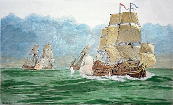
 The terms pirate and privateer are unclear to many people, but there was a clear distinction which was made between the two in the past, even if a shadowy grey area did exist for many people. In fact, during the Age of Sail, one man’s privateer was often another man’s pirate. First we must look at what a pirate is. The word itself is derived with the Greek peiratēs, meaning brigand, and like a brigand or bandit there were no restrictions on whom they attacked. They were outlaws plain and simple, possessing no legal commission, or one which covered the specific act of aggression they carried out. They often had their own flags, usually only flying the flag of a nation under false colours to trick their prey, although those pirates who considered themselves patriots might have flown the flag of their own nation too. They usually obtained their vessel by means of mutiny or capture.…
Category: Pirate way of life
Navigational instruments
Astrolabe
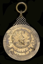 This device is thought to have been first developed by the ancient Greeks, the term astrolabe meaning ‘star taker.’ It is a primitive inclinometer that calculates the altitude of the sun and stars to determine latitude. An astrolabe can be used for both astronomy and navigation at sea. Elaborate astrolabes can have etchings of how the sky looks at any given time or season. Sailors used this device by lining it up with the sun or a specific star, such as the North Star, in relation to the horizon in order to measure latitude vertically. This helped sailors to determine their location while at sea. Astrolabes came in a variety of shapes, such as a sphere or as flat plates and disks, and were made of metal, usually brass or iron, the former ensuring longevity at sea. A disadvantage was that astrolabes were cumbersome and could be difficult to use on the rolling deck of a ship.…
Sailing distances from Nassau
In the early eighteenth century travel by ship was the only way to reach many destinations. Progress was often slow, the distances covered were great, and time spent at sea unbearably long. The following table shows the distances those sailing to and from Nassau, New Providence sailed and the number of days usually required to cover that distance. Ships sailing from Europe to the Americas and back followed the trade winds. The North Atlantic trade winds blow from east to west at about 30 degrees latitude, which meant ships leaving Europe first sailed south and then veered west at the Canary Islands. On the return journey ships would use the Gulf Stream, which first went north along the coast of New Spain, turning north-east across the North Atlantic to Europe.